Location of Lambina Opal Field
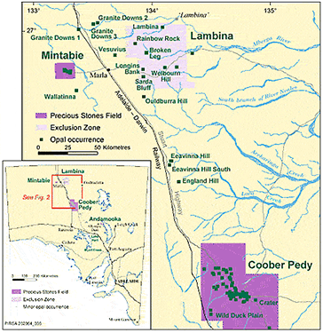
Lambina Opal field is 58km northeast of the town of Marla, 90km northeast of Mintabie Opal field, and 10km south of Lambina Homestead. Access to this remote area is either from the Stuart Highway eastwards along the road to Granite Downs and Lambina, and then along the old Oodnadatta Road that leaves this road ~60km east of Granite Downs and 5km south of Lambina Homestead, or east from Marla 11km then northeast to Broken Leg diggings and generally northwards to Lambina Opal field. The latter access is the preferred route taken by miners. Tracks from the Seven Waterholes area lead to various ‘diggings’ around Lambina (Barnes et al., 1992). Large map locates the opal field and its surrounding ‘diggings’.
Initial Discovery
Lambina Opal field was likely discovered in the 1930s, but not reported on until 1956. Visited and worked only intermittently in the 1950s, 1964, 1978 (Flint, 1980; Hiern, 1967), and then worked seriously from 1989 to the mid 1990s. When available opaliferous ‘ground’ at Mintabie appeared to be diminishing, a few miners tried their luck at the Seven Waterholes diggings (at the western end of the opal field). When word spread of their success, many others attempted to take out opal claims over this occurrence which appeared to spread eastwards. As Lambina Opal field was located on a pastoral lease, the legislation required to take out a mineral claim for opal was cumbersome and gaining access was not easy.
Background To Lambina Opal Field
Background To Lambina Opal Field
Barry Lindner, President of the Mintabie Progress Association, and later the South Australia Opal Miners’ Association (SAOMA) and former Department of Minerals and Energy Resources, became guarantors for rehabilitation of ‘diggings’, with funds collected from a bond levied on each miner taking out a lease near Lambina. This streamlined the process, but there was still much paperwork involved.
Native title issues were solved by having the appropriate Aboriginal community make a native title claim, providing a group with whom the miners could negotiate. The Lambina Native Title Agreement between SAOMA and the traditional owners – the Antakirinja and Yunkuntjatjara people – was signed on 1 June 1998. Lambina and its surrounds, therefore, became accessible to opal miners, and more than 200 claims were registered over the next four months (see MESA Journal 11, pp.28-29 for further information).
The Aboriginal people negotiated first rights to noodle (fossick) for opal on the bulldozed dumps from open-cut operations, and miners were allowed to camp on an area set aside for camping. Not proclaimed a Precious Stones Field, no permanent residences would be allowed on the opal field, no PIRSA officer stationed on site, and miners had to travel to Marla to register claims. Coober Pedy now coordinates operations at Lambina and Mintabie. An exclusion zone was proclaimed over Lambina in the mid-1990s to allow miners access to potential opal-bearing areas. Mineral exploration licence holders cannot include exploration for opal in the terms of the licence
Production at Lambina Opal Fields
Opal production from fields throughout Australia is difficult to estimate. By using a formula determining the amount of mining activity via the number of active claims and documenting the amount of equipment on particular opal fields. An estimate of production is made in South Australia every six months and then combined into a calendar or financial year total. Table 1 provides annual estimates of Lambina opal production taken from the PIRSA Division of Minerals and Energy records.
Estimates from 1989 to 1998 are unknown in the Mintabie figures. However, since 1999 Lambina’s other Far North opal diggings have been treated as a separate entity, and the estimates from 1995 to 98 are deduced only from discussions. Experts estimate that the total production from Lambina and its immediate surroundings exceeds A$43 million. They assume that production before 1989 was minor compared to recent years, due to the introduction of large mining equipment.
Important!
We have been advised that access is not permitted to the field unless a notice of entry has been served to the station owners 21 days in advance.
Details are available from PIRSA.
Geology and Formation of Opal At Lambina opalfields
Opal at Lambina and other Far North opal ‘diggings’ is hosted mainly in rocks from the Cretaceous age. The age of the opal throughout the Great Artesian Basin (GAB) has been a point of speculation and claimed ages range from Cretaceous to Recent. This has led to a variety of geological models proposed for opal formation.
The formation of Lambina opal was during Tertiary times. This timeframe is similar to most South Australian deposits (the same appears to apply to other opal fields in Australia). Weathered sediments of the Great Artesian Basin (GAB) and generally Cretaceous-age host rocks associate with the opal. Mintabie stands out as the exception, hosting opal in significantly older material. These materials also exhibit weathering and feature onlapping Cretaceous sediments (Townsend, 1981). However, erosion has removed much of these sediments, leaving only remnants around Mintabie and outliers further west.
Influences of Palaeochannels
Tertiary palaeochannels (ancient river channels), present on many opal fields, play a role in opal genesis. These channels, typically coarse-grained sand bodies with high porosity, have served as pathways for water movement, facilitating silica movement and opal deposition in nearby areas. Additionally, faulting or fault zones, often linked to opal formation, act as conduits for silica-rich groundwater.
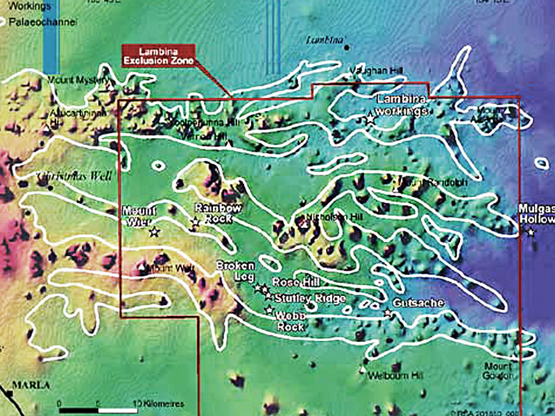
The digital elevation model (DEM) of Lambina (Fig. 1 below) indicates the possibility of remnant channels trending east to west. Opal occurrences in the area extending from Lambina through to Todmorden Outstation and south to Eeavinna Hill and England Hill occur in ‘breakaway’ country of mesas and eroded plains that cut into the Early Cretaceous Bulldog Shale.
Indicative signs
These mesas (topographic highs, shown in red) associate with opal occurrences, and the interpreted paleochannels appear in white (Fig. 1).
The palaeochannels originally began as topographic lows – stream channels that were later silicified during the Tertiary and now remain as highs caused by a reversal in topography resulting from erosion of the softer surrounding Tertiary and weathered Cretaceous sediments since late Tertiary times.
Digital elevation model of Lambina and other Far North opal diggings. A number of east-west-trending mesas interpreted as remnant palaeochannels are outlined in white.
Fig. 1
Potential Future Sources of Opal
As the occurrence of opal in northern South Australia is so widespread — several hundred kilometers north of Coober Pedy on 1:250 000 map areas such as WINTINNA, ABMINGA and through to Mintabie opal field on EVERARD – there appears to be much potential ranging from England Hill (Townsend and Scott, 1981) in the south and Lambina opal fields (Flint, 1980) to the north, Todmorden to the east and Mintabie to the west. This area of at least 10,000 km2 includes sporadic occurrences of opal adjacent to mesas and, more importantly, contains remnants of palaeochannels.
Interpretation of remote sensing data will assist in further discoveries of opal, as shown using DEM pseudocolour images of Coober Pedy, Andamooka, and now Lambina opal fields and their surrounds. At Mintabie, Andamooka and Coober Pedy, the diggings were already known before the creation of the DEM images however, in northern South Australia, there is only a sprinkling of known opal occurrences over a large area of ‘breakaway’ landscape. Closer-spaced airborne surveys to produce more detailed DEM images in selected areas should assist in this exploration.
Acknowledgements
References
The author thanks the PIRSA Division of Minerals and Energy for assistance with the photographs. Generated from the Coober Pedy office and the provision of map images from PIRSA Spatial Information Services and Publishing Services.
For further information, contact Jack Townsend (Ph: 08 8297 4799, Email: townsend.jack@myaccess.com.au)
Barnes, L.C., Townsend, I.J., Robertson, R.S., and Scott, D.C.— 1992
Opal: South Australia’s Gemstone
South Australia Department of Mines and Energy.Handbook, 5.
Brown, G., Townsend, 1.J. and Endor, K.— 1993
Some Far Northern Opal Diggings in South Australia
Australian Gemmologist, 18(8):252-25.
Flint, D.J.— 1980
Lambina Opal Diggings.
South Australia Department of Mines and Energy. Report Book, 80/103.
Hiern, M.N.— 1967
Opal Deposits in Northern South Australia
Mining Review, Adelaide, 122:37-39.
Horton, D.— 2002
Australian Sedimentary Opal — Why Is Australia Unique?
Australian Gemmologist, 21(8):278-294.
Primary Industries and Resources South Australia— 1998
Lambina Native Title Agreement
MESA Journal, 11:28-29.
McCallum, W.S.— 1980
Vesuvius Opal Diggings
South Australia Department of Mines and Energy. Report Book, 80/38.
Townsend, 1.J. and Robertson, R.S.— 1980
Wallatinna Opal Diggings
South Australia Department of Mines and Energy. Report Book, 80/34.
Townsend, I.J. and Scott, D.C.— 1981
Sarda Bluff, Ouldburra Hill, and England Hill Opal Diggings
South Australia Department of Mines and Energy. Report Book, 81/17.
Townsend, I.J.— 1981
Discovery of Early Cretaceous Sediments at Mintabie Opal Field
South Australia Geological Survey. Quarterly Geological Notes, 77:8-15.
Townsend, I.J.— 1990
Mintabie Opal Field: Mining and Geology
South Australia Geological Survey. Quarterly Geological Notes, 117:8-15.


